During the Bay Area’s damp winters, we can’t afford to be fair-weather hikers. Fortunately, some hikes in the Bay Area are best enjoyed in the rainy winter months. While vistas might be engulfed in foggy voids and trails on clay-rich soils become mud baths, rain awakens the forest floor for up close views of amphibians, slugs, mosses and mushrooms.
From lush creeks to waterfalls, here are six hikes to help you revel in the soggy season. Some caveats: We’re talking drizzle, or overcast day after a good soak; we don’t generally recommend hiking during a rainstorm (and never if lightning is forecast!). Always check trail conditions before you go, whether on park websites or Alltrails ^(https://www.blogquicker.com/goto/https://www.alltrails.com/).
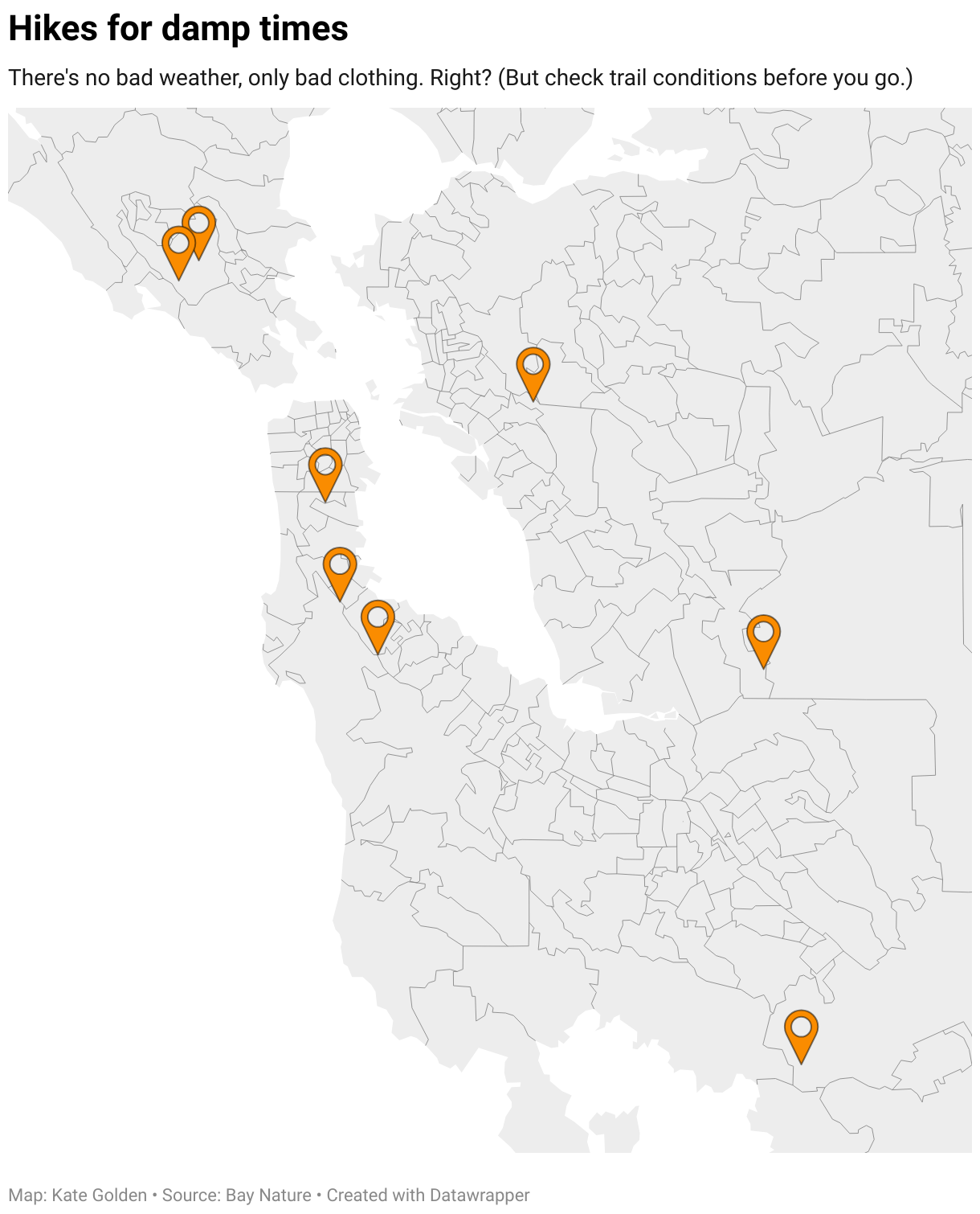
SOUTH BAY
Uvas Canyon Waterfall Loop
Uvas Canyon County Park, Morgan Hill, Santa Clara County
This lively loop trail ^(https://www.blogquicker.com/goto/https://files.santaclaracounty.gov/exjcpb1516/2024-11/uvas-canyon-guide-map.pdf?VersionId=fxsylS1Vc8oEJl9imV6dfWGx6qrTpMMY) features six waterfalls! Nestled into the eastern side of the Santa Cruz Mountains, the trail follows Swanson Creek as it cascades down steep gulches coated in ferns and littered with moss-covered boulders. The trail meanders through a mixed evergreen forest of California bay laurels, Douglas firs, madrones, black oaks, canyon live oaks, and stands of young redwoods. In winter, keep an eye out for clusters of ladybugs near the bridge crossing Black Rock Falls. Woodpeckers, quail, vultures and wild turkeys are also common in the area. Gentle, soaking rains will draw out banana slugs and California newts crossing roads and trails, and if you’re lucky you may even spot a Pacific giant salamander.
A shorter loop option follows the 1-mile Waterfall Nature Trail, which has numbers matching a self-guided interpretive pamphlet you can pick up from a box near the trailhead. If you are following this shorter loop, turn around at Myrtle Flats, which is named after the invasive vinca vine.
For a longer, more challenging loop, continue past Myrtle Flats onto the steeper Contour Trail. At 2.3 miles in, continue onto the Alec Canyon Trail up to the Manzanita Point lookout. Keep going on the Alec Canyon Trail and turn right onto a spur for a climactic view of Triple Falls. Return down the Alec Canyon Trail to a fire road, which leads back toward the parking lot to complete the loop.

Distance: Waterfall Nature trail loop: 1 mile (easy)
Full Waterfall Loop: 4.5 miles (moderately challenging)
Getting there: 8515 Croy Rd Morgan Hill, CA 95037, Uvas Canyon Parking lot and trailhead ^(https://www.blogquicker.com/goto/https://www.google.com/maps/place/Uvas+Canyon+County+Park/@37.0850335,-121.8309,13z/data=!4m6!3m5!1s0x808e2323e57d745b:0x5b44cb806b9a64f3!8m2!3d37.0850335!4d-121.7922762!16zL20vMDc5a2tz?entry=ttu&g_ep=EgoyMDI0MTIwNC4wIKXMDSoASAFQAw%3D%3D).
To check trail conditions and closures, call 408-355-2200 x4.
Know before you go: Uvas Canyon County park requires parking reservations ^(https://www.blogquicker.com/goto/https://gooutsideandplay.org/reservations/Product.asp?CategoryID=1081134) and a $6 vehicle fee seven days a week. Dogs are allowed on leash. Make sure to check for trail closures on Santa Clara Parks website here ^(https://www.blogquicker.com/goto/https://parks.santaclaracounty.gov/closures).
PENINSULA
Crystal Springs Regional Trail
San Mateo County Parks, Redwood City
If you’re looking for a long walk with minimal mud, the paved, six-mile-long Sawyer Camp segment of the Crystal Springs Trail provides. This accessible trail saunters along the shore of Crystal Springs Reservoir, which fills a valley formed by the San Andreas Fault. Look for fog-shrouded conifers on the hill across the water, bald eagles, and a 600-year-old Jepson laurel tree at the trail’s midpoint.

Located in the valley between Highway 280 and Skyline Boulevard near Redwood City, the trail can be accessed from multiple trailheads ^(https://www.blogquicker.com/goto/https://www.smcgov.org/media/149831/download?inline=) and enjoyed as an out-and-back hike of varying lengths, from the Hillcrest Boulevard trailhead to the north or the Crystal Springs Road trailhead to the south.
Distance: Six miles of paved trail total from trailhead to trailhead (moderately challenging)
Getting there: Hillcrest Boulevard trailhead (north ^(https://www.blogquicker.com/goto/https://www.google.com/maps/place/Portol%C3%A0+Expedition+Camp+Historical+Landmark/@37.588947,-122.4131545,280m/data=!3m1!1e3!4m14!1m7!3m6!1s0x808f75d6dae5ef37:0x6c914b9402597210!2sSawyer+Camp+Trail+South+Trailhead!8m2!3d37.5310073!4d-122.3639574!16s%2Fg%2F11qb6b8fl7!3m5!1s0x808f77635b1fb49d:0x642b5ef3f26ab47c!8m2!3d37.588931!4d-122.413156!16s%2Fg%2F11tjpfqnl1?authuser=0&entry=ttu&g_ep=EgoyMDI1MDExMC4wIKXMDSoJLDEwMjExMjMzSAFQAw%3D%3D))
Crystal Springs Road trailhead (south ^(https://www.blogquicker.com/goto/https://www.google.com/maps/place/Sawyer+Camp+Trail+South+Trailhead/@37.5286632,-122.3665806,2244m/data=!3m1!1e3!4m14!1m7!3m6!1s0x808f75d6dae5ef37:0x6c914b9402597210!2sSawyer+Camp+Trail+South+Trailhead!8m2!3d37.5310073!4d-122.3639574!16s%2Fg%2F11qb6b8fl7!3m5!1s0x808f75d6dae5ef37:0x6c914b9402597210!8m2!3d37.5310073!4d-122.3639574!16s%2Fg%2F11qb6b8fl7?authuser=0&entry=ttu&g_ep=EgoyMDI1MDExMC4wIKXMDSoJLDEwMjExMjMzSAFQAw%3D%3D))
Peninsula
Mountain Bog Trail
San Bruno Mountain, San Mateo County
At the foot of San Bruno Mountain just south of San Francisco, the 0.8-mile Mountain Bog Trail loop rambles through brambles, sedges, rush hedges, and ferny nooks. While it may not feature epic views or majestic redwoods, the bog offers a spot close to the heart of San Francisco to sit and think with the mud. Willows, coyote brush, coffeeberry, and dogwood thrive in moist crannies. If you are unfamiliar with the joys of a bog in the rain, this is a great place to get acquainted. At dusk, you may hear owls.

For an extension to a 3-mile loop, continue along the paved Old Guadalupe Road trail and Saddle Trail around back to the parking lot.
Distance: 0.8 mile-loop for just the bog; 3-mile loop including paved trails. (Easy)
Getting there: San Bruno Mountain Parking Lot Trailhead ^(https://www.blogquicker.com/goto/https://www.google.com/maps/place/San+Bruno+Summit+Loop/@37.6973636,-122.4361145,17z/data=!4m14!1m7!3m6!1s0x808f79526ee97501:0xaafd78f90be8c22e!2sSan+Bruno+Mountain!8m2!3d37.6874329!4d-122.436361!16zL20vMDg5NWoy!3m5!1s0x808f7eb2113835c9:0x30bcbe2e273bf67f!8m2!3d37.696843!4d-122.4339418!16s%2Fg%2F1vd95b5m?authuser=0&entry=ttu&g_ep=EgoyMDI0MTIwNC4wIKXMDSoASAFQAw%3D%3D), Guadalupe Canyon Pkwy, CA 95814
EAST BAY
Canyon View Trail to Alameda Creek Overlook
Sunol Regional Wilderness, Alameda County
This gravel trail follows Alameda Creek through rolling green hills, oak woodlands and outcrops of sandstone and serpentine rock, then saunters into a dramatic canyon formerly known as Little Yosemite, ending with a charming small waterfall. The area is very exposed, making it more enjoyable on overcast or rainy days, especially when the creek and small waterfalls are flowing.
Begin at the Sunol Visitor’s Center, cross the bridge over the creek, and turn right onto the Canyon View Trail. Turn right onto Camp Ohlone Road through the gorge, then right again onto the McCorkle Trail to return to the Canyon View Trail and complete the loop.
Distance: 4.5-mile lollipop loop (moderately challenging)
Getting there: Sunol Visitor Center Trailhead ^(https://www.blogquicker.com/goto/https://www.google.com/maps/place/Sunol+Visitor+Center/@37.516078,-121.8344444,17z/data=!3m1!4b1!4m6!3m5!1s0x808fc5a16c49b45f:0x481225be081843bf!8m2!3d37.5160738!4d-121.8318695!16s%2Fg%2F1tf6b8rb?authuser=0&entry=ttu&g_ep=EgoyMDI0MTIwNC4wIKXMDSoASAFQAw%3D%3D), 1895 Geary Rd, Sunol, CA 94586
Know before you go: Dogs are allowed.
EAST BAY
Stream Trail and French Trail Loop
Reinhardt Redwoods Regional Park, Alameda County
Tucked in the Oakland hills, majestic stands of third-growth redwoods tower over Redwood Creek in Reinhardt Redwoods Regional Park ^(https://www.blogquicker.com/goto/https://www.ebparks.org/sites/default/files/maps/R%20Redwood_2020-9-15-1.pdf), offering a drippy wonderland that swallows you up in its hush. Rain awakens an orchestra of sharp evergreen and bay laurel aromas, and brings out the textures of bark and frothy lichen beards dangling from branches. The park’s menagerie of loopy trails offers different levels of difficulty and length options from the Canyon Gate parking lot.

For a paved, mostly flat out-and-back option, you can follow the Stream Trail to meander along the creek—a great place to look for salamanders and slugs roaming the carpet of redwood needles. Continue along the trail for 0.9 miles to Trails End, which has pit toilets and water and the Stream Trail becomes unpaved, and turn around.
For a longer, more challenging loop, continue on the Stream Trail past Trail’s End and turn left on the Chown Trail to switchback up the ravine. The Chown Trail is steep, and can get slippery with mud after intense rain. Next, turn left onto the French Trail to continue along a ridge shrouded in fog on rainy days. Turn left again to descend back down the ravine on the Orchard Trail and then the Bridle Trail, which reconnects with the Stream Trail to return to the Canyon Meadow Staging Area parking lot.
Distance: 1.8-mile out-and-back on the Stream Trail (moderately difficult)
Or, try a 3.3-mile loop following Stream Trail, Chown Trail, French Trail and Bridle Trail (challenging, with options to go longer and steeper if you go further up the ridge).
Getting there: Canyon Meadow Staging Area ^(https://www.blogquicker.com/goto/https://www.google.com/maps/place/Canyon+Meadow+Staging+Area/@37.8068078,-122.1509232,790m/data=!3m1!1e3!4m6!3m5!1s0x808f88ed8557d357:0x1f63bd09dcb69de8!8m2!3d37.8068036!4d-122.1483483!16s%2Fg%2F11g9mbhjtr?authuser=0&entry=ttu&g_ep=EgoyMDI1MDEyMi4wIKXMDSoASAFQAw%3D%3D), Oakland, CA 94619


Convergent lady beetles overwinter on the Stream Trail; mushrooms, possibly genus Psathyrella (brittlestems), sprout from a tree trunk on the French Trail at Reinhardt Redwoods. (Kate Golden)
NORTH BAY
Bon Tempe Lake Loop
Mt. Tamalpais watershed, Marin County
Scenic at every step, this mostly flat lakeside romp takes you through both rolling grassland and redwood forest as it circumnavigates Bon Tempe Lake on the northeastern slope of Mount Tamalpais. Fog shrouds the reservoir lake, which becomes a destination for amphibians after the mountain has gotten a good winter season soak. Look out for rough-skinned newts, California newts, ensatinas, and salamanders ambling along the forest floor as you make your way around the lake. This is also a lovely area for birding, with wild turkeys, northern shovelers, occasional osprey, and herons spotted in winter months.
The trail begins at the Lake Lagunitas parking lot ^(https://www.blogquicker.com/goto/https://www.marinwater.org/sites/default/files/2020-09/Watershed%20Visitor%20Map.pdf). Follow the Shadyside Trail along the forested side of the lake to do the loop counterclockwise, or go on the Sunnyside trail to begin with the grassland to go clockwise. This area is very popular for fishing, so be aware of anglers on the shoreline.
Distance: 3.7-mile loop (moderately challenging, minimal elevation change)
Getting there: Bon Tempe Lake Trailhead ^(https://www.blogquicker.com/goto/https://www.google.com/maps/place/Bon+Tempe+Lake+Trailhead/@37.9583395,-122.6099942,66m/data=!3m1!1e3!4m6!3m5!1s0x808596be6c236d47:0xf1281c1f3f2de96d!8m2!3d37.9591167!4d-122.6098333!16s%2Fg%2F11csqd_fyw?authuser=0&entry=ttu&g_ep=EgoyMDI1MDEyMS4wIKXMDSoASAFQAw%3D%3D), Bon Tempe Dam Rd, Fairfax, CA 94930
North Bay
Cataract Falls, High Marsh Trail and Alpine Lake Loop
Mt. Tamalpais, Marin County
If you’re looking for a strenuous adventure that comes to life in winter, Cataract Falls is for you, though be prepared to turn around if mud or slick wooden stairs make the trail unsafe. Cataract Creek gushes and tumbles down a steep slope of moss-coated boulders through one of many redwood-lined gullies along the northern slopes of Mount Tamalpais. Take in earthy scents and the spit-splatter of raindrops on lush fronds as you huff and puff up at least 168 stairs. If the mountain has had a truly good soak, the quieter, flatter remainder of the loop is festooned with newts, salamanders, and fungi of all shapes and sizes. The waterfall portion of the trail is very popular, so be prepared to brave the crowds on weekends.

The trail begins at the Alpine Lake reservoir, then embarks up a rugged ascent as it follows the falls. Look out for wild rose, hazelnut, and huckleberry shrubs in the understory, and watch your step on slippery stairs! After a steep 1-mile trek, arrive at the base of the main waterfall.
Just past the falls is the junction with the High Marsh Trail, which meanders across a serene meadow shrouded in fog. After 2 miles, turn left on the Kent Trail, and be cautious as this section is steep and may be slick. Turn left again onto the Helen Markt trail, which follows the shore of Alpine Lake back to the trailhead.
Distance: 2.8-mile out and back to the top of the falls (Challenging; very steep and potentially slippery ascent up to Cataract Falls). Or, take a 6.5-mile loop (Challenging; very steep and potentially slippery ascent up to Cataract Falls, plus a long loop).
Getting there: Cataract Falls Trailhead ^(https://www.blogquicker.com/goto/https://www.google.com/maps/place/Cataract+Trailhead/@37.9365189,-122.6560932,15z/data=!4m10!1m2!2m1!1sCataract+Falls,+High+Marsh+Trail+and+Alpine+Lake+Loop,+Mt.+Tamalpais,+Marin+County!3m6!1s0x80859406166055b5:0x5a2a3b551f6463fd!8m2!3d37.9365191!4d-122.6380675!15sClJDYXRhcmFjdCBGYWxscywgSGlnaCBNYXJzaCBUcmFpbCBhbmQgQWxwaW5lIExha2UgTG9vcCwgTXQuIFRhbWFscGFpcywgTWFyaW4gQ291bnR5WlAiTmNhdGFyYWN0IGZhbGxzIGhpZ2ggbWFyc2ggdHJhaWwgYW5kIGFscGluZSBsYWtlIGxvb3AgbXQgdGFtYWxwYWlzIG1hcmluIGNvdW50eZIBC2hpa2luZ19hcmVhmgEjQ2haRFNVaE5NRzluUzBWSlEwRm5TVVJrTW1JeVVFNTNFQUXgAQD6AQQIQhBJ!16s%2Fg%2F11bcf13f6t?entry=ttu&g_ep=EgoyMDI0MTIwNC4wIKXMDSoASAFQAw%3D%3D), Bolinas–Fairfax Rd, Bolinas, CA 94924. The trailhead is on the left side of the road at a hairpin turn, shortly after crossing the Alpine Lake dam.
#RainyDay #Hikes #Bay #Area